

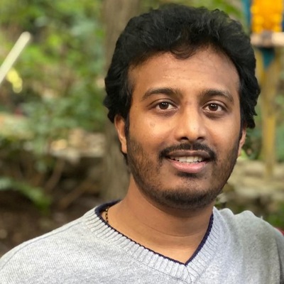
Sandeep Kumar Chittimalli
Synectics for Management Decisions Inc, Sr Data Scientist, Contractor for large Federal Organization located in DC, USA.
Fuquay-Varina, North Carolina, United States
Actions
Sandeep kumar Chittimalli is a Senior Data Scientist and AI/ML Expert specializing in Artificial Intelligence, Machine Learning, Data Science, Earth Science, Remote Sensing, and Satellite Image Processing, with more than a decade of experience driving innovation across federal, scientific, and academic research domains. He currently serves as Chair of the IEEE Geoscience and Remote Sensing Society (GRSS), East North Carolina Section (ENCS) and is a Senior Member of IEEE GRSS, Board Member of GCSAYN, and Chair of the GCSAYN Research Committee Advisory Group, while also serving as an IET Advisor and AI Collective Research Triangle Chapter Lead. He currently leads AI/ML and data science initiatives at Synectics supporting a large federal organization in the United States and has a long-standing history of supporting high-impact federal research projects. His past contributions encompass prestigious organizations including NASA, the U.S. Geological Survey (USGS), and the South Dakota State University (SDSU) Image Processing Laboratories. With dual master’s degrees in Electrical Engineering and Electronics, Sandeep excels in architecting scalable data science environments, automating complex workflows, processing and analyzing satellite imagery, and delivering actionable insights through advanced AI/ML model development and deployment. He brings deep expertise in applying artificial intelligence and machine learning across a wide range of scientific, technical, and operational applications, enabling data-driven solutions and enhancing mission-critical decision-making in federal and research domains. Sandeep has extensive experience working with both federal and academic research projects, successfully translating complex scientific and operational goals into innovative, scalable, and data-driven solutions. His multidisciplinary expertise enables him to bridge advanced AI/ML methodologies with Earth science, remote sensing, satellite image processing, image analysis, and scientific computing, addressing complex challenges involving large-scale and high-dimensional datasets. As an active contributor and recognized expert within the technical and research community, Sandeep has served as a judge and reviewer for numerous research, technology, and innovation events, as well as for well-known national and international conferences and peer-reviewed journals. Through these roles, he has contributed to the evaluation of research and emerging technologies across diverse areas of science, engineering, artificial intelligence, machine learning, and data science. He is known for providing constructive, timely, and rigorous evaluations and for supporting the recognition, advancement, and dissemination of high-quality research and innovative ideas. Through his professional leadership and community engagement, Sandeep is committed to advancing the fields of Artificial Intelligence, Machine Learning, Data Science, Earth Observation, Remote Sensing, and intelligent systems. He remains passionate about staying at the forefront of emerging technologies and continuously exploring new ways to apply AI and data-driven approaches to solve complex real-world problems. Through technical leadership, research, mentorship, professional service, and collaboration, he continues to push the boundaries of what is possible with intelligent systems while contributing to the growth of the broader scientific, engineering, and AI communities.
Links
Area of Expertise
Topics
Agentic RAG for Federal Decision Science: Applying LLMs to High-Stakes Program and Funding Decisions
This session covers how large language models can be used to support complex, high-impact decisions when data and evidence are spread across many documents, systems, and scientific sources. In many real situations, the challenge is not a lack of information, but the effort required to find relevant evidence, connect it across sources, identify gaps or conflicting information, and make sense of it within a limited amount of time.
We use federal Earth science and Earth-observation scenarios to make the problem concrete. The examples draw on scientific and program information from NASA, NOAA, USGS, EPA, and related federal sources, including research solicitations and award portfolios, satellite and remote-sensing products, technical reports, policy guidance, operational monitoring information, and funding records. The scenarios include AI/ML research and funding analysis, scientific portfolio overlap, operational readiness, uncertainty, and the use of Earth-observation missions and sensors such as NASA PACE, Landsat, Sentinel-2, MODIS, VIIRS, and Sentinel-3. Water-quality remote sensing provides one practical example, but the approach is applicable more broadly to Earth science, satellite imagery, AI/ML-enabled research, scientific program planning, research funding, and other high-stakes federal decision-support problems.
We focus on a practical approach called agentic Retrieval-Augmented Generation (RAG). Instead of relying on a single model to answer questions, we describe systems where multiple LLM-based agents work together. One agent gathers relevant material, another checks evidence across sources, and another pulls the information together while highlighting uncertainty. Topics include keeping model outputs grounded in real data, dealing with inconsistent information, evaluating source relevance and recency, identifying possible overlap or gaps across funded research, and understanding where models can fail. The same framework can help connect scientific evidence with program priorities, funding history, operational needs, and mission-specific constraints.
The goal of this talk is not automation, but better decision support. Agentic RAG can help analysts and decision makers spend less time manually searching across scientific reports, satellite and Earth-observation information, research portfolios, funding records, policy documents, and operational data, and more time evaluating evidence and making informed decisions. Attendees will leave with a clear, realistic picture of how agentic RAG can support high-impact scientific and program decisions while keeping human experts responsible for final judgment.
Target audience: Data scientists, AI/ML practitioners, Earth and environmental scientists, federal program and research analysts, technical leaders, and professionals interested in responsible LLM/RAG-based decision support.
Preferred session duration: 30–45 minutes, with additional time for Q&A.
Technical requirements: None.
Additional information: The session uses practical federal Earth science and Earth-observation examples based on publicly available NASA, NOAA, USGS, and EPA materials, including research portfolios, funding information, scientific reports, and satellite missions/sensors such as PACE, Landsat, Sentinel-2, MODIS, VIIRS, and Sentinel-3. No advanced knowledge of RAG is required; basic familiarity with AI/ML is helpful.
Sandeep Kumar Chittimalli
Synectics for Management Decisions Inc, Sr Data Scientist, Contractor for large Federal Organization located in DC, USA.
Fuquay-Varina, North Carolina, United States
Links
Actions
Please note that Sessionize is not responsible for the accuracy or validity of the data provided by speakers. If you suspect this profile to be fake or spam, please let us know.
Jump to top